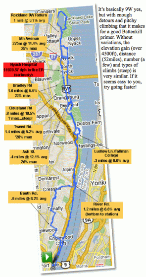
It’s basically 9W yes, but with enough detours and pitchy climbing that it makes for a good Battenkill primer. Without variations, the elevation gain (over 4500ft), distance (52miles), number (a few) and types of climbs (steep) is very similar. If it seems easy to you, try going faster!
Cue Sheet
…the usual on 9W until downtown Piermont…
-L on Ash St.
-L at switchback
-R at the end of the street
-L on 9W (50 yards)
-R on Tweed Blvd. to Clausland Mtn. Intersection (2 miles)
*Variation 1 (adds 5 miles and Clausland Climb)
-Continue thru intersection on N. Tweed Blvd (1.4miles)
-L on Bradley Hill Rd. (.5miles)
-L on Schuyler Rd/Bradley Pkwy (.5miles)
-L on Rte 11/Greenbush Rd (1.5miles)
-pass Rte 303
-L on Clausland Rd/Rte 28 (1.2miles)
*Variation 2 (reverse loop adds 5 miles and Bradley Hill Climb)
*Doing both adds over 800ft. of extra climbing
-L at Clausland/Tweed Intersection (1.2miles)
-R on Rte/Greenbush Rd (1.5miles)
-R on Schuyler Rd/Bradley Pkwy (.5 miles)
-R on Bradley Hill Rd. (.5miles)
From Clausland/Tweed Intersection
-R on South Blvd (1.4miles)
-Continue past I-287 intersection onto 9W (4miles)
-R into Rockland Lake State Park
-do the loop if you so desire
-L on 9W (1.5miles)
-L on Christian Herald Rd. (.5miles) …follow bike signs
-L on Old Mountain Rd (.3miles)…follow bike signs
-R on N. Broadway (.8miles)
-R on 5th Ave. (275meters)
-L on N. Midland Ave (.2miles)
-L on High Ave (.4miles)
-R on Broadway…coffee and a muffin
-L on Main
-R on Piermont Ave (3.5miles)
-R on Ash St. (yes, again)
-L on 9W…cross bridge…(2.2miles)
-L on Oak Tree Rd…traffic light (.3miles)
-R on Ludlow Ln. (1mile)
-L on 9W (5.3miles)
-R on Hillside Ave (1.5miles of speed…no lights or stops)
-L on 501 and follow thru cemetary.(2miles)
-L on Booth Ave. (1mile)
-R on Woodland St (.5miles)
-L on Palisades, passing 9W and you’re home free!

